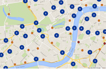
TfL launches new interactive collision map showing 'safety history' of London streets
The map is designed to improve safety awareness and shows collision history around the capital dating back to 2005


Transport for London has this week launched it's 'London Collision Map', an interactive way for road users to see historic data on incidents around the capital.
The data, collected together by the police and TfL, dates back to 2005 and is according to TfL, is aiding "TfL’s commitment to improve transparency for customers and stakeholders."
>>> Chris Boardman explains why cyclists ride two abreast in new safety video
The launch of the collision map comes as the Mayor of London and TfL publish Annual Safety Report for the last 12 months, which they say shows the number of killed or seriously injured fell to it's lowest ever point.
Despite that, a number of protest 'die-ins' have been held around London this year already, with eight cyclists having been killed on London roads in 2015, and 13 the year before.
Watch: Hovding Airbag
TfL says it already uses collision data to make road safety improvements, with a proposed £4bn Road Modernisation Plan, including safer junctions and new segregated and partially-segregated cycle lanes, as well as road safety and cycle training across London's boroughs.
Get The Leadout Newsletter
The latest race content, interviews, features, reviews and expert buying guides, direct to your inbox!
“Safety continues to improve on London’s roads, but we are not complacent," said Deputy Mayor for Transport, Isabel Dedring.
"It is a top priority and that’s why the Mayor set a new target to bring down the number of people killed or seriously injured even further.
"This map is part and parcel of our drive to improve road safety awareness and complements ongoing work to overhaul and improve London’s key roads and junctions.”
You can view the new beta version of the collision map by visiting the following link.

Thank you for reading 20 articles this month* Join now for unlimited access
Enjoy your first month for just £1 / $1 / €1
*Read 5 free articles per month without a subscription

Join now for unlimited access
Try first month for just £1 / $1 / €1
Follow on Twitter: @richwindy
Richard is digital editor of Cycling Weekly. Joining the team in 2013, Richard became editor of the website in 2014 and coordinates site content and strategy, leading the news team in coverage of the world's biggest races and working with the tech editor to deliver comprehensive buying guides, reviews, and the latest product news.
An occasional racer, Richard spends most of his time preparing for long-distance touring rides these days, or getting out to the Surrey Hills on the weekend on his Specialized Tarmac SL6 (with an obligatory pub stop of course).
-
 'I'd love to be an F1 driver': Get to know GB track sprinter Emma Finucane
World sprint champion tells Cycling Weekly about her earliest Olympics memories, drinking coffee in Jakarta, and her passion for F1
By Tom Davidson Published
-
 'I felt like I was the worst rider in the bunch' - Simon Carr dispels doubt with longest ever solo win at Tour of the Alps
Brit triumphs from lone 45km breakaway, after days of battling allergies
By Tom Davidson Published